
By Rebecca A. Hunt
What is in a name?
The lower section of Northwest Denver has had many names and identities since the 1850s. In the winter of 1858, when William Larimer and others laid out the western bank of the Platte River, they called it Highland.

In 1874 and then in 1883, parts of it became North Denver as Denver annexed the area between the river and Gallup Street (now Zuni Street), south to Lake (Speer), then north to Prospect (now 38th Avenue). In the 20th century, mapmakers transformed the neighborhood into Lower Highland. Since the 2010s the area has carried the trendy name of LoHi.
This name was the brainchild of marketing expert Lu Stasko and her friend, Paul Tamborello, who led early redevelopment of Lower Highland. But in the 19th century it all began as Highland. An early drawback to settlement of Highland was lack of a bridge. The first bridge in Denver came in 1860 and was the project of Thomas Bayaud. It crossed at what is now 15th Street.
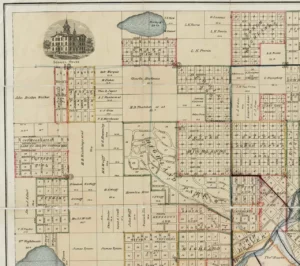
designed around the turn of the century. Photo Courtesy of Denver Public Library’s Western History Collection
This should have led to a land rush to the area, but that was not to be. A few years after maps showed a platted neighborhood with named streets and inviting lots, gold miner José Merival looked the place over to see if it might be a good investment.
He determined that his horse and saddle, which he could have used as collateral, was worth more than the land. Only a few hardy settlers moved over to the Northside. Esther Frazier and her family had settled at 613 4th Street in Highland by 1861. We know about Esther because of a painting she did of Cheyenne and Arapaho people on the hills overlooking the new town of Denver.
The late 1860s and early 1870s would finally bring in a few more families and business owners. Over time, North Denver would become a working-class and immigrant section of the Northside. Some of the land west of Gallup opened up for those wanting to take up a homestead under the 1862 Homestead Act. One of those souls was Walter McDuffie Potter, a tubercular Baptist missionary preacher who arrived in Denver in 1863.
The American Baptist Home Society sent him out to Colorado for his health and to set up a church for Baptists who had decided to try their luck in the fledgling city of Denver. But Potter found fundraising difficult and the first set of donations to build a church in Auraria only allowed the group to construct a basement to a larger planned structure.
Dubbed the “Holy Dugout,” it served until a new building could be built in the 1870s. In the meantime, Reverend Potter began to buy up land, including an area on what is now nineteenth street, near the river. He and his sister Lucy filed on a homestead of 320 acres across the river from Denver.
The boundaries of his property were what is now West 32nd Avenue, north to 38th Avenue, west to Federal Boulevard and east to Zuni Street. He began to lay out blocks and lots, thinking that he could sell them to fund his church project in Denver.
Unfortunately, both Walter and Lucy became so ill with tuberculosis that they had to go back east. Walter died in 1866 at age 29. He left the land to the Baptist Missionary Society for future work in Colorado. At the same time, the local Baptists claimed Potter Highlands, as it was now called, for their work.
Many years later, after much negotiation and litigation, the land went to the local First Baptist Church. Sale of that land helped fund a bigger church, and eventually the current building at Grant and 14th Avenue near the state capitol.
Potter Highlands eventually became a core neighborhood for an independent town named Highland. Next month we will explore the stories of Highland, Potter Highlands, and Highland Park.
Dr. Rebecca A. Hunt has been a Denver resident since 1985. She worked in museums and then taught Colorado, Denver and immigration history at the University of Colorado Denver until she retired in 2020.
Rebecca, thank you for beginning this work of cataloging our neighborhood histories. I hope that after your next installment, you’ll move a bit south to my neighborhood, Jefferson Park. A good segue could be that our Fire Dept site used to host the majestic Highlands Town Hall, and the land where the Safeway sits at 26th and Federal used to be a stagecoach stop in the 1860s. Across from our street (which has the only row of 7 Victorian Queen Anne’s in Jeff Park) used to be The Cozy Bread Co. and the Old Homestead Bakery (according to a 1904 platte) and on 25th and Eliot, our erstwhile Sarto’s Restaurant was, of course, a tailor shop. It seems that the neighborhood has always been a mix of blue and white collar (with the latter, like my home’s first owner who caught the trolley on Lake and taking it to the Interstate Trust Bldg on 16 St for decades, and the Woodbury mansion that was demolished for Diamond Hill). Please bring your expertise down our way and I’d love to help if I can!
Don,
I will contact you when I do Jefferson Park. It is good to know you are available with such a store of knowledge.
Regards, Rebecca